
Bà Rịa地形图
点击地图以显示海拔。
关于这张地图
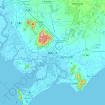
名称:Bà Rịa地形图、海拔、地势。
地点:Bà Rịa, Ho Chi Minh City, 78106, Vietnam (10.33724 107.00780 10.65724 107.32780)
平均海拔:28 米
最低海拔:-4 米
最高海拔:498 米
其他地形图
点击地图以查看其地形、其海拔和其地势。
Ho Chi Minh City
Ho Chi Minh City is located in the south-eastern region of Vietnam, 1,760 km (1,090 mi) south of Hanoi. The average elevation is 5 m (16 ft) above sea level for the city centre and 16 m (52 ft) for the suburb areas.[53] It borders Tây Ninh Province and Bình Dương Province to the north, Đồng Nai Province…
平均海拔:26 米
Ho Chi Minh City
Ho Chi Minh City is located in the south-eastern region of Vietnam, 1,760 km (1,090 mi) south of Hanoi. The average elevation is 5 m (16 ft) above sea level for the city centre and 16 m (52 ft) for the suburb areas. It borders Tây Ninh Province and Bình Dương Province to the north, Đồng Nai Province and…
平均海拔:26 米
Đà Nẵng
Geologically, Da Nang is at the edge of a Paleozoic fold belt known as the Truong Son Orogenic Zone, whose main deformation occurred during the Carboniferous period. Da Nang's topography is dominated by the Annamite Range to the north and north-west, which features peaks ranging from 700 to 1,500 m (2,300 to…
平均海拔:355 米
Đà Nẵng
Geologically, Da Nang is at the edge of a Paleozoic fold belt known as the Truong Son Orogenic Zone, whose main deformation occurred during the early Carboniferous period. Da Nang's topography is dominated by the steep Annamite mountain range to the north and north-west, which features peaks ranging from 700…
平均海拔:355 米
Sa Pa
Vietnam > Lao Cai province > Xã Tả Van
The Hoàng Liên Sơn mountain range, which includes Vietnam's highest mountain, Fansipan, dominates the area. Situated at an average elevation of about 1,600 m (5,200 ft), Sa Pa is characterized by a montane ecosystem. Remnants of old-growth forest featuring unique trees like the critically endangered…
平均海拔:1,270 米
Ninh Thuận Province
Ninh Thuận's topography is typical for the South Central Coast in that high mountains are located not only near the western border to the Central Highlands, but also near the coast, the highest of which is Chúa mountain (Vietnamese: Núi Chúa) at 1,040 metres (3,410 ft) in the north east of the province.…
平均海拔:186 米
Thái Nguyên Province
The Tam Đảo mountain region is protected by the Tam Đảo National Park, established in 1996, which is one of the largest national parks in the country. There are over 20 peaks with the park area, others of note include Thien Thi at 1,375 m, Thach Ban at 1,388 m and Phu Nghia at 1,300 m. Sharp peaks with…
平均海拔:323 米
Lâm Đồng Province
The three highest plateaus of the Central Highlands: Lâm Viên, Di Linh, and Bảo Lộc (formerly known as B'Lao), are located in Lâm Đồng province at an elevation of 1,500 meters above sea level. The provincial capital, Đà Lạt City, is situated 300 km northeast of Ho Chi Minh City, 658 km south of…
平均海拔:181 米
Ninh Thuận Province
Ninh Thuận's topography is typical for the South Central Coast in that high mountains are located not only near the western border to the Central Highlands, but also near the coast, the highest of which is Chúa mountain (Vietnamese: Núi Chúa) at 1,040 metres (3,410 ft) in the north east of the province.…
平均海拔:186 米
Đồng Tháp Province
The topography of the province is quite flat with a sloping tendency from north to south and west to east, separating it into two large regions: one to the north of the Tiền River, having an area of 250,731 hectares (619,570 acres), in the Đồng Tháp Muoi area; and one to the south of the Tiền River,…
平均海拔:6 米
Ninh Thuận Province
Ninh Thuận's topography is typical for the South Central Coast in that high mountains are located not only near the western border to the Central Highlands, but also near the coast, the highest of which is Chúa mountain (Vietnamese: Núi Chúa) at 1,040 metres (3,410 ft) in the north east of the province.…
平均海拔:186 米
Lâm Đồng Province
The three highest plateaus of the Central Highlands: Lâm Viên, Di Linh, and Bảo Lộc (formerly known as B'Lao), are located in Lâm Đồng province at an elevation of 1,500 meters above sea level. The provincial capital, Đà Lạt City, is situated 300 km northeast of Ho Chi Minh City, 658 km south of…
平均海拔:181 米
Ho Chi Minh City
The city is located in the south-eastern region of Vietnam, 1,760 km (1,090 mi) south of Hanoi. The average elevation is 5 m (16 ft) above sea level for the city centre and 16 m (52 ft) for the suburb areas. It borders Tây Ninh Province and Bình Dương Province to the north, Đồng Nai Province and Bà…
平均海拔:26 米
Điện Biên Province
Thẳm Khến Cave (also known locally as Chùa Ta Cave): Located at an altitude of nearly 1,000m above sea level, in a limestone mountain range with a geological tectonic process of millions of years, Tham Khen cave in Muong Dun commune, Tua Chua district has also been recognized by the Ministry of Culture.…
平均海拔:897 米
Lâm Đồng Province
The three highest plateaus of the Central Highlands: Lâm Viên, Di Linh, and Bảo Lộc (formerly known as B'Lao), are located in Lâm Đồng province at an elevation of 1,500 meters above sea level. The provincial capital, Đà Lạt City, is situated 300 km northeast of Ho Chi Minh City, 658 km south of…
平均海拔:181 米
Pleiku
Pleiku is located at an average altitude of 700m - 800m; Ham Rong junction, or the junction of National Highway 14 and National Highway 19 south of Pleiku, has an altitude of 785m.
平均海拔:724 米
Ho Chi Minh City
The city is located in the south-eastern region of Vietnam, 1,760 km (1,090 mi) south of Hanoi. The average elevation is 5 m (16 ft) above sea level for the city centre and 16 m (52 ft) for the suburb areas. It borders Tây Ninh Province and Bình Dương Province to the north, Đồng Nai Province and Bà…
平均海拔:26 米