
Argentière地形图
点击地图以显示海拔。
Argentière
Argentière (French pronunciation: [aʁʒɑ̃tjɛʁ]) is a picturesque skiing, alpine walking and mountaineering village in the French Alps, part of the commune of Chamonix-Mont-Blanc, at an altitude of 1,252 m (4,108 ft).
关于这张地图
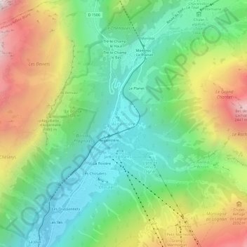
名称:Argentière地形图、海拔、地势。
平均海拔:1,674 米
最低海拔:1,177 米
最高海拔:2,547 米
其他地形图
点击地图以查看其地形、其海拔和其地势。
Glacier des Bossons
France > Auvergne-Rhône-Alpes > Upper Savoy > Chamonix-Mont-Blanc
In 1900 the snout of the glacier was still reaching down into the valley bottom at an altitude of 1,050 metres above sea level. By 1980 the snout only reached down to about 1,200 metres, and by 2008 it had melted backwards even further backwards, ended at around 1,400 metres, albeit still well below the…
平均海拔:3,138 米
Mer de Glace
France > Auvergne-Rhône-Alpes > Upper Savoy > Chamonix-Mont-Blanc
The glacier lies above the Chamonix valley. The pressure within the ice is known to reach at least 30 atmospheres. The Mer de Glace can be considered as originating at an elevation of 2,100 metres (6,900 ft), just north of the Aiguille du Tacul, where it is formed by the confluence of the Glacier de Leschaux…
平均海拔:2,323 米