
Iztaccíhuatl地形图
点击地图以显示海拔。
Iztaccíhuatl
The name "Iztaccíhuatl" is Nahuatl for "White (like salt) woman", reflecting the four individual snow-capped peaks which depict the head, chest, knees and feet of a sleeping female when seen from east or west. Iztaccíhuatl is to the north of its twin Popocatépetl, to which it is connected by the high altitude Paso de Cortés. Depending on atmospheric conditions Iztaccíhuatl is visible much of the year from Mexico City some 70 km (43 mi) to the northwest. The first recorded ascent was made in 1889, though archaeological evidence suggests the Mexica and previous cultures climbed it previously. It is the lowest peak containing permanent snow and glaciers in Mexico.
关于这张地图
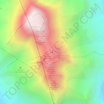
名称:Iztaccíhuatl地形图、海拔、地势。
地点:Iztaccíhuatl, San Salvador el Verde, Puebla, Mexico (19.17015 -98.63764 19.17025 -98.63754)
平均海拔:4,732 米
最低海拔:4,293 米
最高海拔:5,221 米