
Kālāhandi地形图
点击地图以显示海拔。
关于这张地图
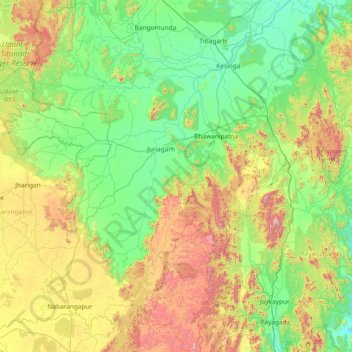
名称:Kālāhandi地形图、海拔、地势。
地点:Kālāhandi, Kalahandi District, Odisha, India (19.05000 82.30000 20.45000 83.70000)
平均海拔:452 米
最低海拔:122 米
最高海拔:1,498 米
其他地形图
点击地图以查看其地形、其海拔和其地势。
Mayurbhanj
Mayurbhanj's geography is defined by the Simlipal National Park located in the centre of the district. Covering more than a fourth of the district's area, these forests surround the Simlipal Hills, which form the watershed for the district dividing the district into distinct east and west regions. Elevations…
平均海拔:239 米
Abdul Kalam Island
In May 2013, increasing concern has been drawn to the change of the island's topography, owing to sand erosion. Since the island is technically a shoal, seawater frequently causes sand-shifting. The DRDO sought the assistance of geological experts from National Institute of Ocean Technology to monitor the…
平均海拔:1 米
Rayagada
The district's tribal population is 57.52 percent of the total. Its 11 blocks have been covered by a tribal sub-plan, with three micro-projects in operation for pre-literate indigenous tribal communities. Rayagada's topography helps the tribal communities maintain their cultural identity; 4,785.36 square…
平均海拔:522 米
Angul
Angul is located in the centre of the state of Odisha and lies between the latitudes of 20°31′N and 21°40′N and longitudes of 84°15′E and 85°23′E. The altitude is between 564 and 1,187 metres (1,850 and 3,894 ft). The district has an area of 6,232 km2 (2,406 sq mi). It is bounded by Dhenkanal and…
平均海拔:234 米
Gajapati
The Mahendratanaya River, a tributary of the Banshadhara River, is the primary river flowing through the district. The highest peak in the district is Mahendragiri, standing at 1,501 meters (4,925 feet), followed by Dandamera Parbat at 1,103 meters (3,619 feet) and Tangiri Parbat at 1,155 meters (3,789 feet).…
平均海拔:341 米
Jagatsinghapur
Jagatsinghpur is situated on an elevation of 15 meters (49 feet). It is the smallest district in the state and covers a landmass of 1759 km2. The place lies between 8603' to 86045' East Longitude and between 19058' to 20023' North latitude. It is predominantly recognized due to its triangular geographical…
平均海拔:6 米
Mayurbhanj
Mayurbhanj's geography is defined by the Simlipal National Park located in the centre of the district. Covering more than a fourth of the district's area, these forests surround the Simlipal Hills, which form the watershed for the district dividing the district into distinct east and west regions. Elevations…
平均海拔:239 米
Baripada
India > Odisha > Baripada (M)
Baripada is at 21°56′N 86°43′E / 21.94°N 86.72°E / 21.94; 86.72. It has an average elevation of 36 metres (118 feet). The city lies along the Budhabalanga River.
平均海拔:41 米
Angul
Angul is located in the centre of the state of Odisha and lies between the latitudes of 20°31′N and 21°40′N and longitudes of 84°15′E and 85°23′E. The altitude is between 564 and 1,187 metres (1,850 and 3,894 ft). The district has an area of 6,232 km2 (2,406 sq mi). It is bounded by Dhenkanal and…
平均海拔:234 米