
Malmö地形图
点击地图以显示海拔。
关于这张地图
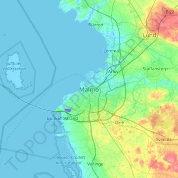
名称:Malmö地形图、海拔、地势。
地点:Malmö, Malmö kommun, Skåne County, 211 34, Sweden (55.44529 12.84016 55.76529 13.16016)
平均海拔:15 米
最低海拔:-59 米
最高海拔:102 米
其他地形图
点击地图以查看其地形、其海拔和其地势。
Ven
Along the entire coast, the island drops steeply towards the sea where the Öresund meets a rocky beach. This steep coast is called Backafall. Ven's backafall is a nature reserve established in 1990. There are no large forests, but smaller stands of trees occur closest to the coast the slightly higher…
平均海拔:13 米
Ven
Sweden > Skåne County > Tuna
Along the entire coast, the island drops steeply towards the sea where the Öresund meets a rocky beach. This steep coast is called Backafall. Ven's backafall is a nature reserve established in 1990. There are no large forests, but smaller stands of trees occur closest to the coast the slightly higher…
平均海拔:13 米
Kullaberg
Sweden > Skåne County > Mölle
Kullaberg (Swedish pronunciation: [kɵlaˈbærj]) is a peninsula and nature reserve of land protruding into the Kattegat in Höganäs Municipality near the town of Mölle in southwest Sweden. The site in the province of Skåne is an area of considerable biodiversity supporting a number of rare species and has…
平均海拔:22 米